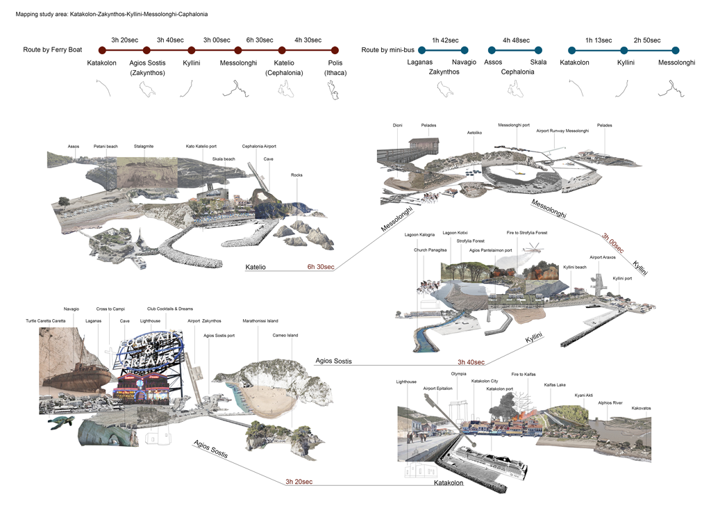
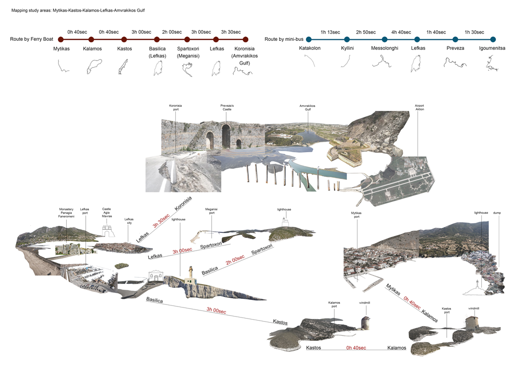
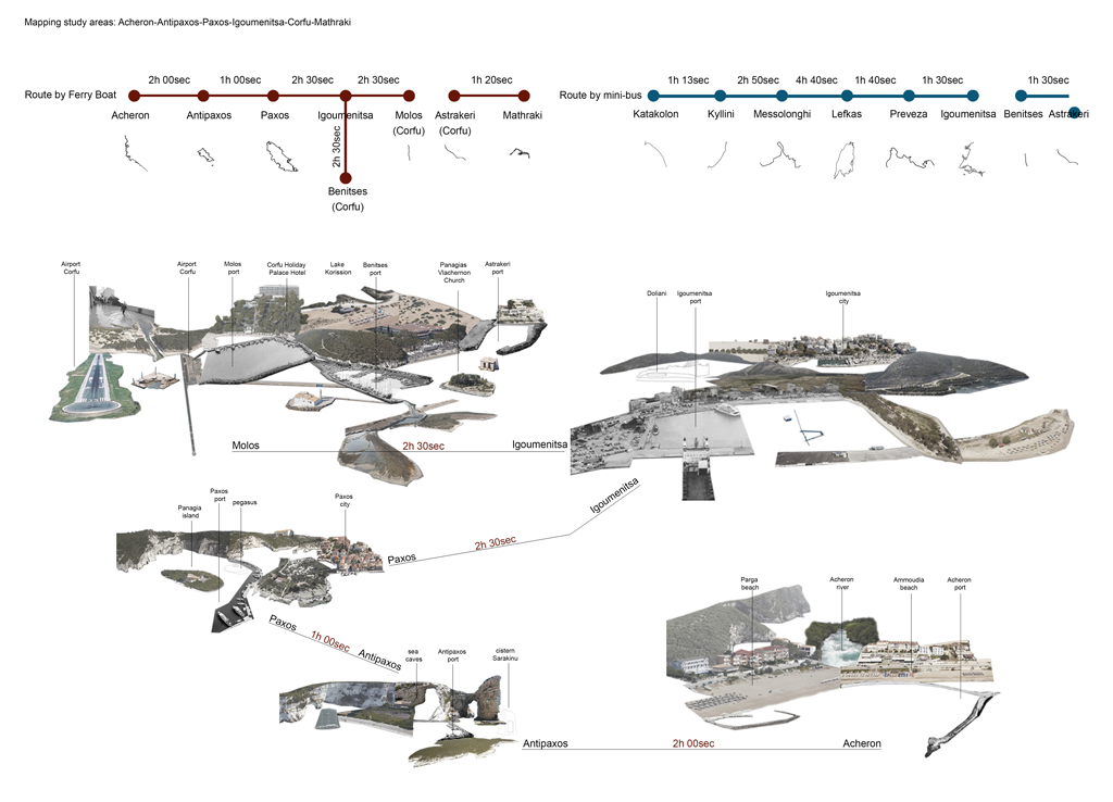
From Natural reserves to Networked Ecologies
Ionian Sea, GR
Aggeliki Stakia, Ioanna Trikogia
Following the mapping investigation of geomorphological, ecological, historical, cultural and economic characteristics of the Ionian Sea region, the research focused upon established maritime connections and the Natura 2000 sites and unveiled the potentialities of their dynamic interconnection.
The proposed system of new routes and eco-tourism activities establishes an integrated approach for the protection, conservation and management of the vulnerable habitats and the upgrading of the existing tourism infrastructure. A new network is thus defined with three ferryboat routes that interconnect ecotourism destinations, activities and accommodation facilities, as well as intermediary stations.

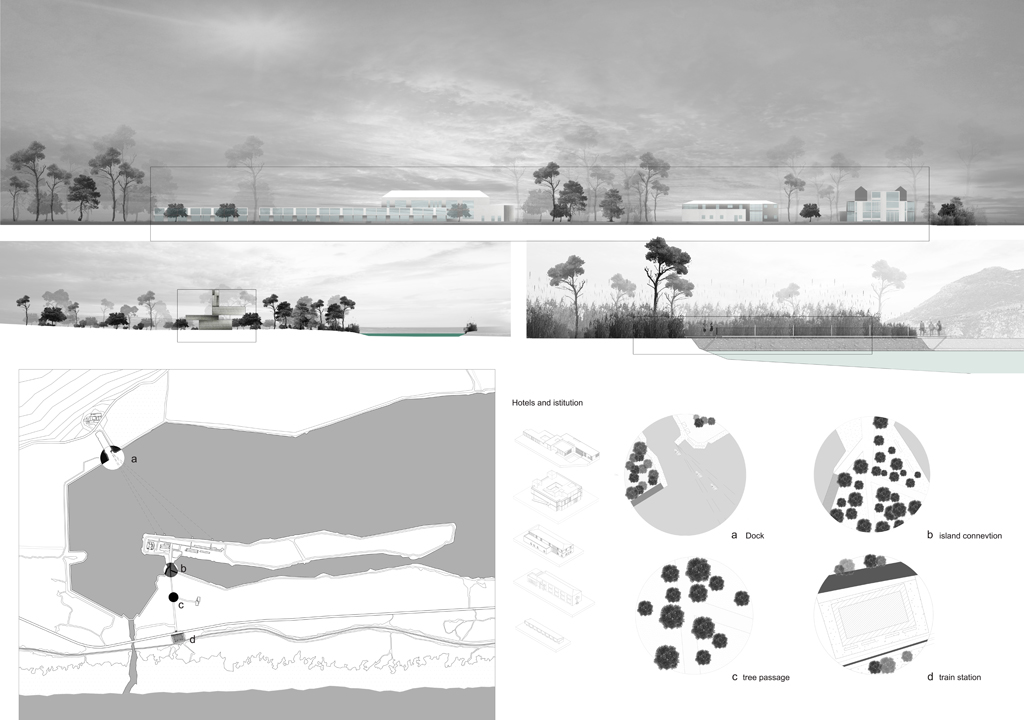
Inhabiting Nature
Kaiafas, Elis, GR
Fotis Ioannis Panagopoulos, Marios Horsch
The Kaiafas complex comprises the Kaiafas Lake, the renowned Thermal Springs, and the Beach, a linear coastline of sand dunes.
The proposed strategy divides the region in three zones: The first zone refers to the coastline. The second, incorporates the railway tracks and the national road. The third zone, includes the lake’s islet, four hotels and their appendices, as well as the Kaiafa Thermal Springs and their infrastructure on the East bank of the lake. The proposed interventions are anticipated to have a minimum impact in response to the importance and vulnerability of the physical environment.
The masterplan redefines the four hotels: two of them will be rebuilt and two fully refurbished, whereas additional thermal baths are introduced. The thermal springs and islet are connected via a new bridge and boat service. The new railway station, following the installation of a second set of fast railway tracks, will improve connectivity and accessibility to the region. The proposed tower-like structure, functions as an info point at ground level and as a viewing platform on its rooftop, unveiling the spectacular panorama above the trees’ canopies.


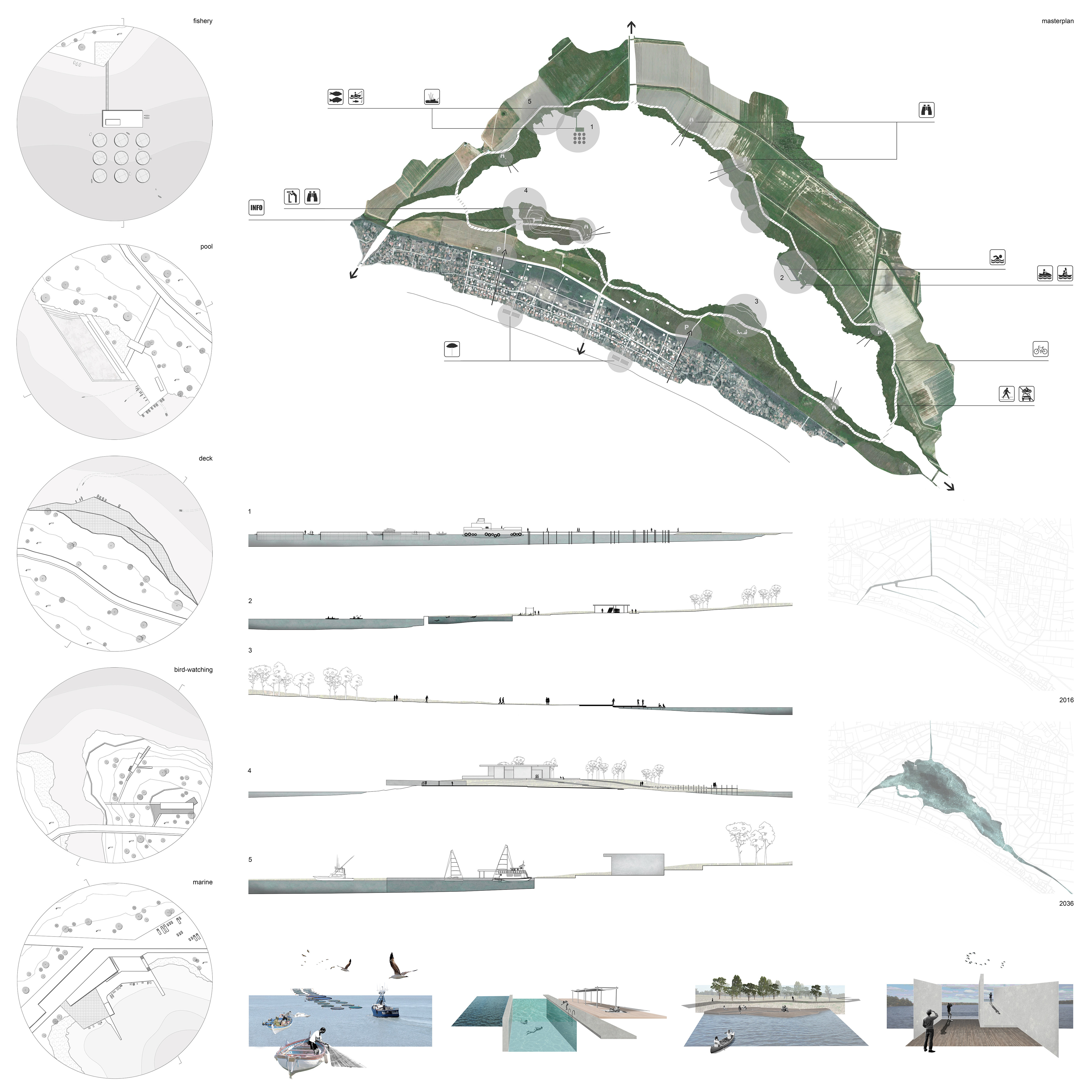
Recostructed Wetland
Kyani Akti, Elis, GR
Aimilia Karkoulia, Katerina Roussou
The scheme re-defines the ecological, cultural and economic potentials of the area through the restoration of the wetland. The re-flooding of Lake Mouria, thus sets the criteria for the rehabilitation and sustainable management of the region. The new lake surrounded by a dense forest and farmland will occupy 2.200 hectares. A small marina for docking fishing and sailing boats, a fish farm, a swimming pool, extensive decks and floating platforms, an info point, bird-watching sheds, will all frame the lake’s coastal zone. A cycling route and pedestrian pathways will interconnect the aforementioned programmes, allowing for the exploration of the area.
Along the seafront zone, the former illegal structures of the existing settlement are attributed new uses that cater for a time-sharing hotel. Thus the houses will be offered as rental accommodation during the tourist season, while during the rest of the year they will be re-used by their original owners. The strategy defines the selective demolition of several existing structures -especially the structures along the seafront-, the remodelling of others and their integration into a new network of blocks, streets and pathways.
Finally, the scheme prescribes new structures for common uses: a piazza, mini market and shops, restaurants and a day-care centre.
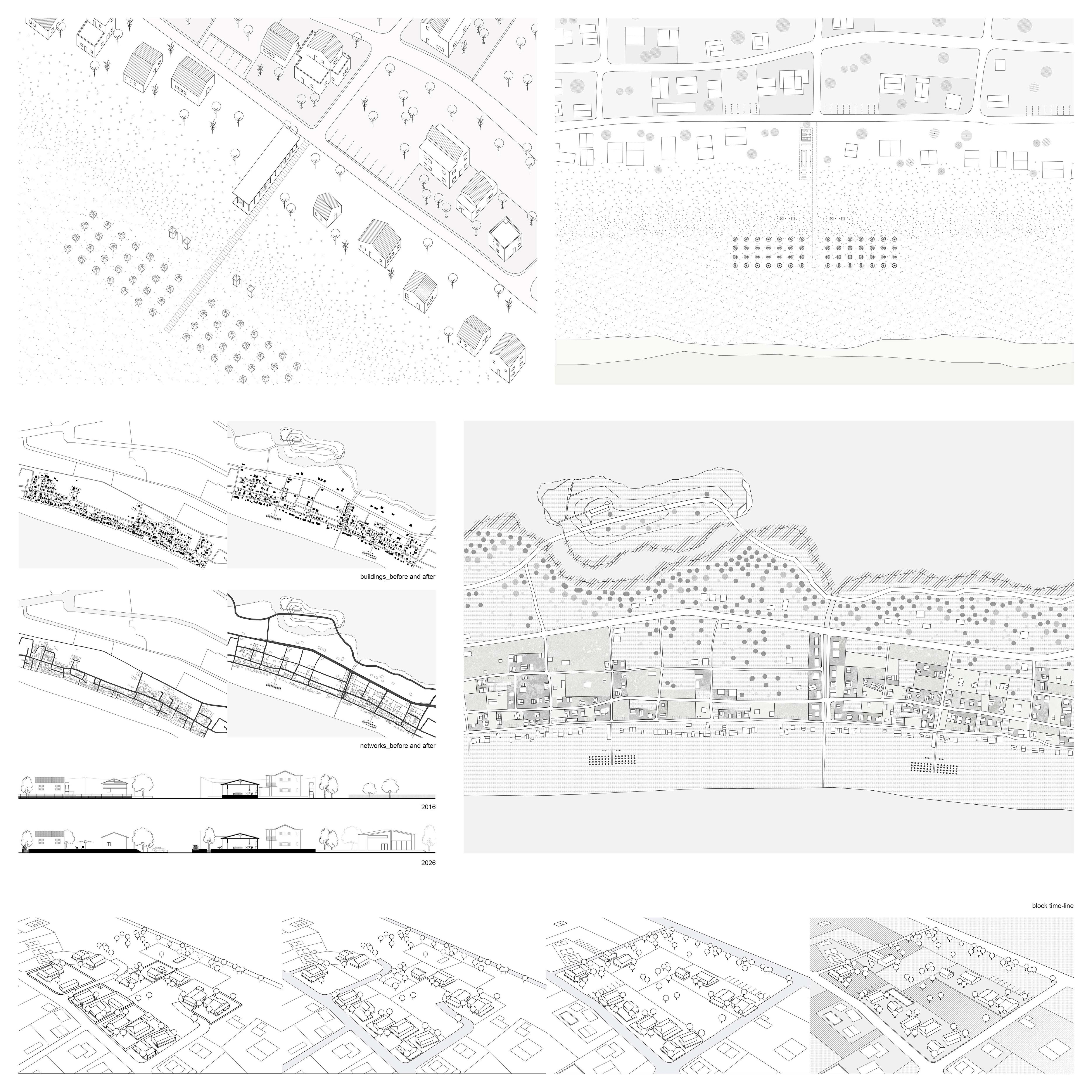
(II)Scales
Katakolon, Elis, GR
Maria Kalaitzaki, Theodora Serdari
The thorough research that preceded the design, revealed poignant issues and deficiencies of Katakolon’s infrastructure. The masterplan anticipating the reopening of the railway connection to Olympia and Kaiafas -which will relieve current traffic problems-, prescribes the creation of a new train and bus terminal as well as a system of pavilions within the town and its archaeological park.
The terminal infrastructure will provide sufficient parking for tourist buses and cars, sheltered waiting areas and a bicycle depot. Furthermore, a large -partly shaded- public piazza with a local products’ market, shops, an exhibition and a lecture hall. The new terminal will be the culmination of a shaded promenade from the quays along the town’s main commercial street. The prescribed shading structures will provide rest areas along the route.
The masterplan defines a new hiking route in the archaeological site of the peninsula, with scattered pavilions at strategic points, offering rest areas and viewing platforms while also accommodating open-air exhibitions and events.
The new slender structures covered with climbing vegetation and PV panels will contribute significantly to the improvement of the area’s microclimate and the minimisation of energy costs and consumption requirements.


EChO-Tourism
Laganas, Zante, GR
Filippos Papadopoulos
Analysing Laganas Town and its surrounding area, amongst many contrasting peculiarities, a rather dominant one concerns the oxymoron and destructive relationship between the seasonal, cheap mass-tourism and the vulnerable ecosystem of the Laganas Bay.
Laganas primarily needs to adjust character through strategic isolation comprising twofold intentions: isolation ‘from’ and ‘to’. The proposed EChO-Tourism strategy, on the one hand, prescribes the implementation of sound-proofing landscaping techniques to restore and protect the vulnerable habitats along the shoreline and the periphery of the settlement and, on the other, aims for a structural economic reform through strategic demolition, infrastructural improvements, intensification and upgrade of the offered tourist product.

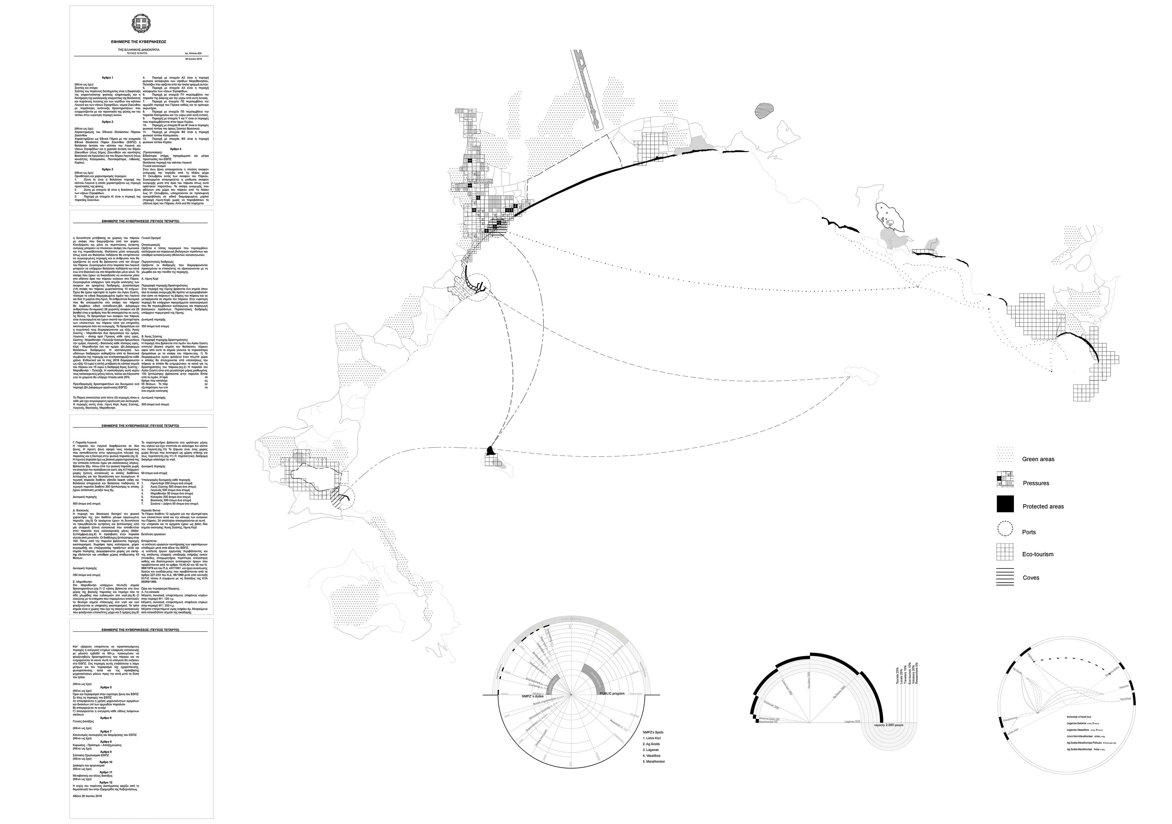
Rehabit-at
Laganas Bay, Zante, GR
Stefania Kontinou, Alexandra Zachariadi
The masterplan outlines a cohesive and realistic strategy for the reorganisation and management of Zante’s National Marine Park (NMPZ).
Based on a thorough understanding of the park’s carrying capacity, regarding visitors and activities, the strategy defines a set of modifications and adaptations to the provisions of the existing legal framework. The proposed contents of a new Government Gazette (Gr. ΦΕΚ) aim to ensure the protection of areas of natural and cultural heritage, as well as several endangered species of animals like the Caretta caretta sea turtle and the Mediterranean Monk Seal, birds, amphibians and flora. The proposed new framework will encourage the development of sustainable tourism and educational activities all through a feasible monitoring and surveillance programme.
Six coastal locations in Marathonissi, Keri, Aghios Sostis, Laganas, Kalamaki and Vassilikos are anticipated to become the Marine Park’s focal points, catering for multiple sustainable activities -sightseeing, awareness activities, marine excursions etc.- while safeguarding the conservation of the natural environment of the NMPZ.


Landscapes of Changes
Dioni, Aetolia & Acarnania, GR
Athina Xenouli
Acheloos’ deltaic environment constitutes a mosaic of ecotones where activities and uses, sometimes conflicting to each other or to the vulnerable ecosystem, appear.
The proposed strategy prescribes the demolition of illegal structures and subsequently the gradual restoration of the coastal zone. Existing -partly- conflicting activities (fishing, livestock grazing, water sports) are re-organised through the creation of three epicentres and interconnected through a newly defined network. Access to each epicentre is achieved by means that safeguard the ground's bearing capacity. Furthermore, the strategy introduces two new flows of connection: the fish and poultry / wool production line from Dioni to Katochi village and the eco-tourism line, in the opposite direction. A new socio-economic and tourism model is thus created, while Katochi is converted into an inland port along the course of Acheloos river.
The proposed, lightweight, elevated, timber structures reflect the traditional ‘pelada’ construction principles assuring that in the new locus the ‘minimum’ is achieved.


IUPP
Platiyali, Aetolia & Acarnania, GR
Prokopis Maragkakis
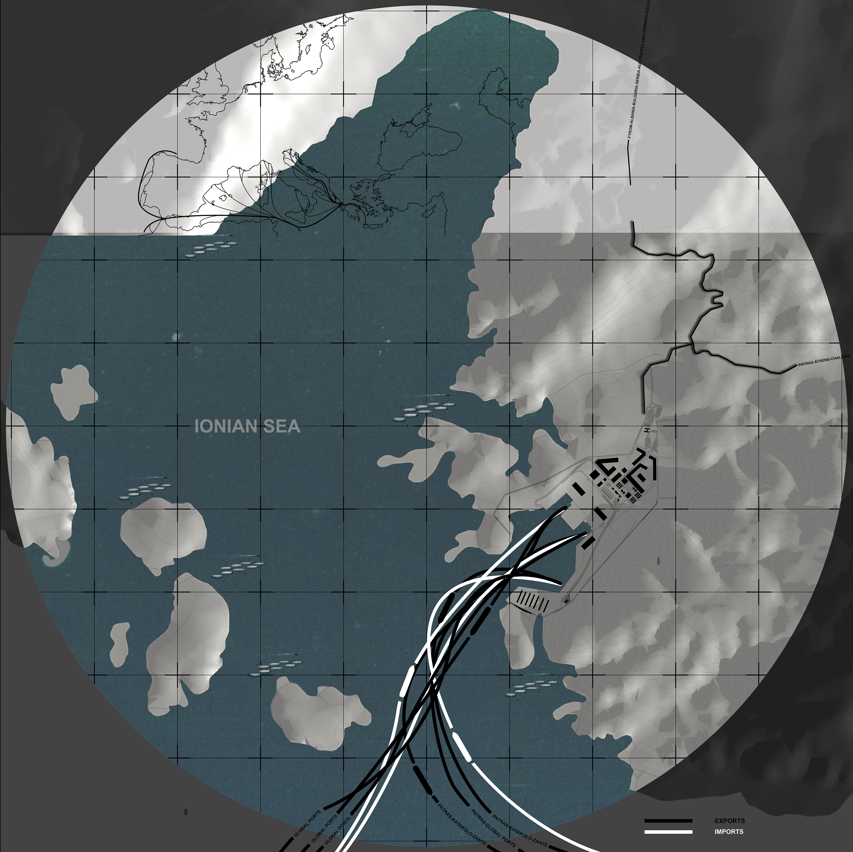
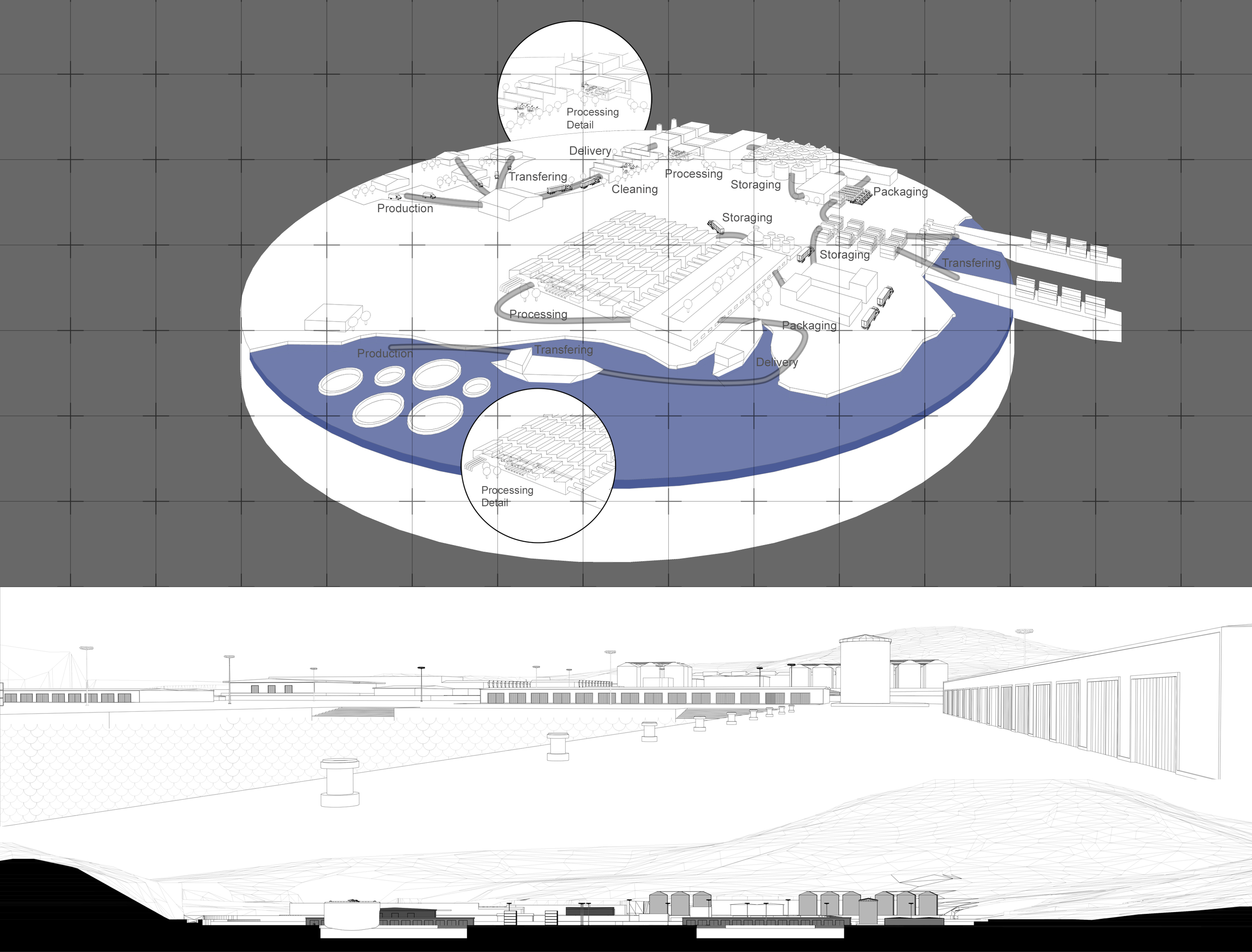
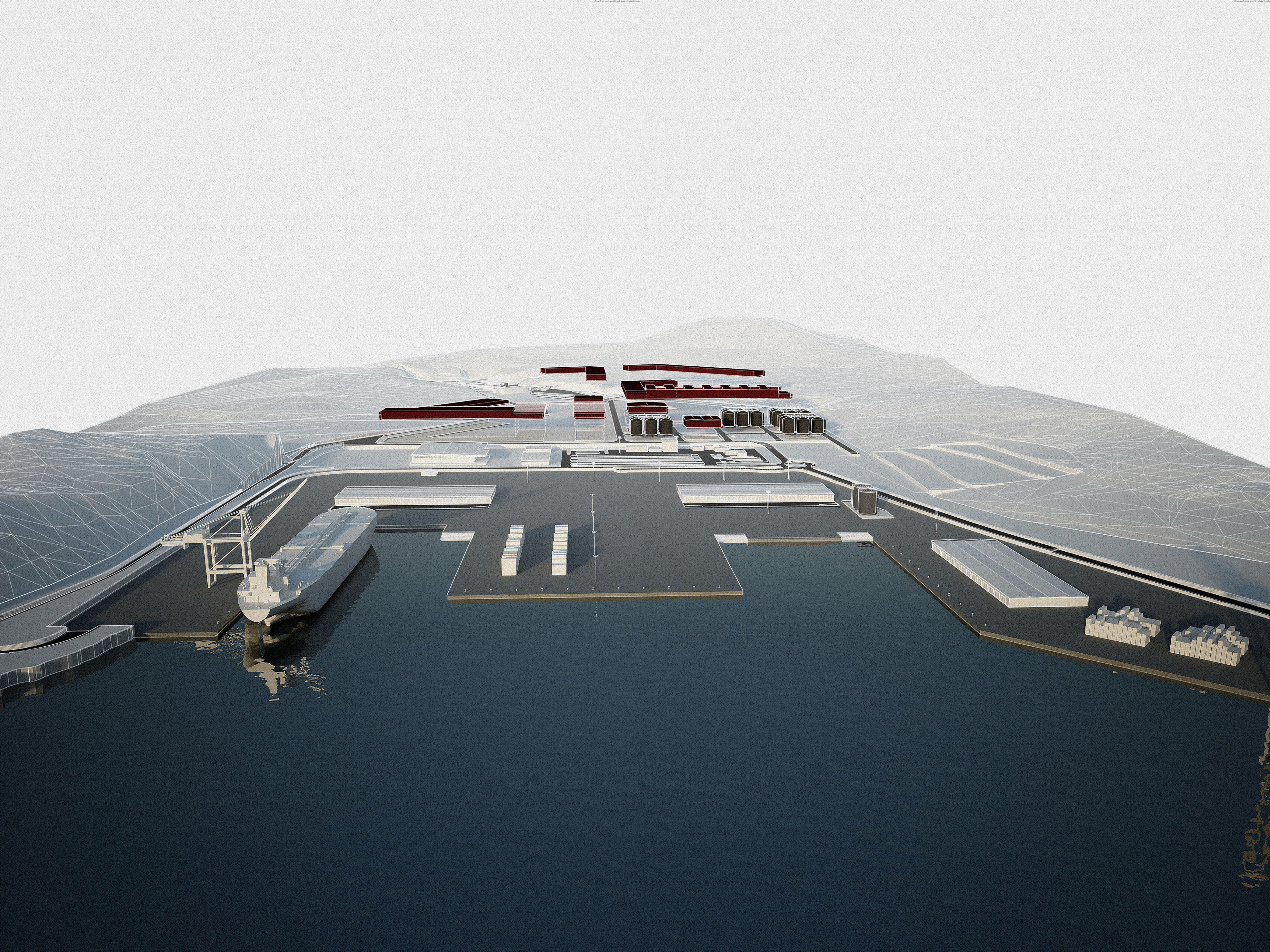
The masterplan, makes use of the trade free zone framework, the location and size of the currently underused harbour infrastructure and proposes a twofold intervention: On a regional scale, it establishes a processing and distribution hub for olive and fishery products that are massively produced in Aetolia and Acarnania, through the upgrading and expansion of the harbour’s existing facilities and the improvement of its connections to the hinterland. On a territorial scale, the scheme projects future political and financial possibilities for interconnecting Platiyali with other Greek, Mediterranean and International ports.
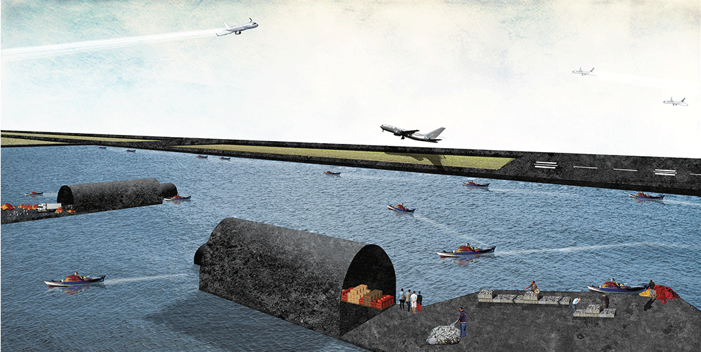
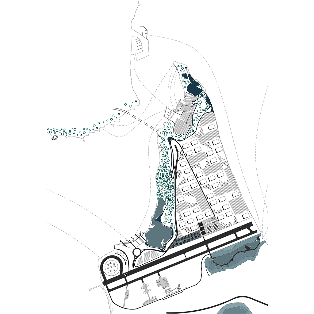
Forward Operations
Actium, Aetolia & Acarnania, GR
Anna Biza, Konstantina Anna Sofianidi
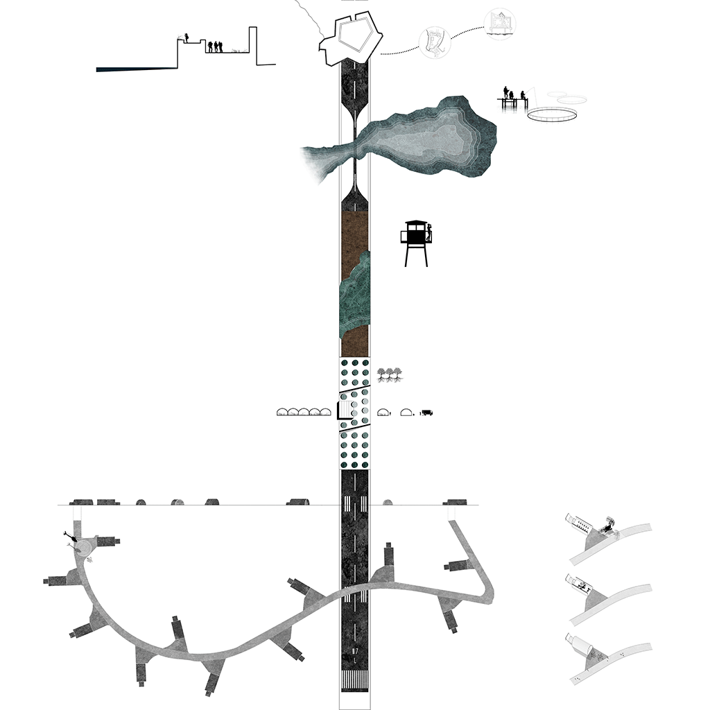
The masterplan envisions the reactivation of the Actium Peninsula but also the redevelopment of the entire Ionian coast through the realisation of a new, independent ‘fortification’ which will leverage and empower the current state of inertia of the region with new networks in air, land and sea space.
To ensure the ‘forward operation’ of existing, enhanced and proposed facilities and infrastructures, three ports are created; an air-port, an earth-port and a sea-port, each one catering for tourism, agriculture and aquaculture production activities respectively.
Actium is anticipated to become the eighth island of the Ionian Eptanissa (Gr. Επτάνησα, Seven Islands) contributing significantly to the redevelopment of Western Greece and the Adriatic region.
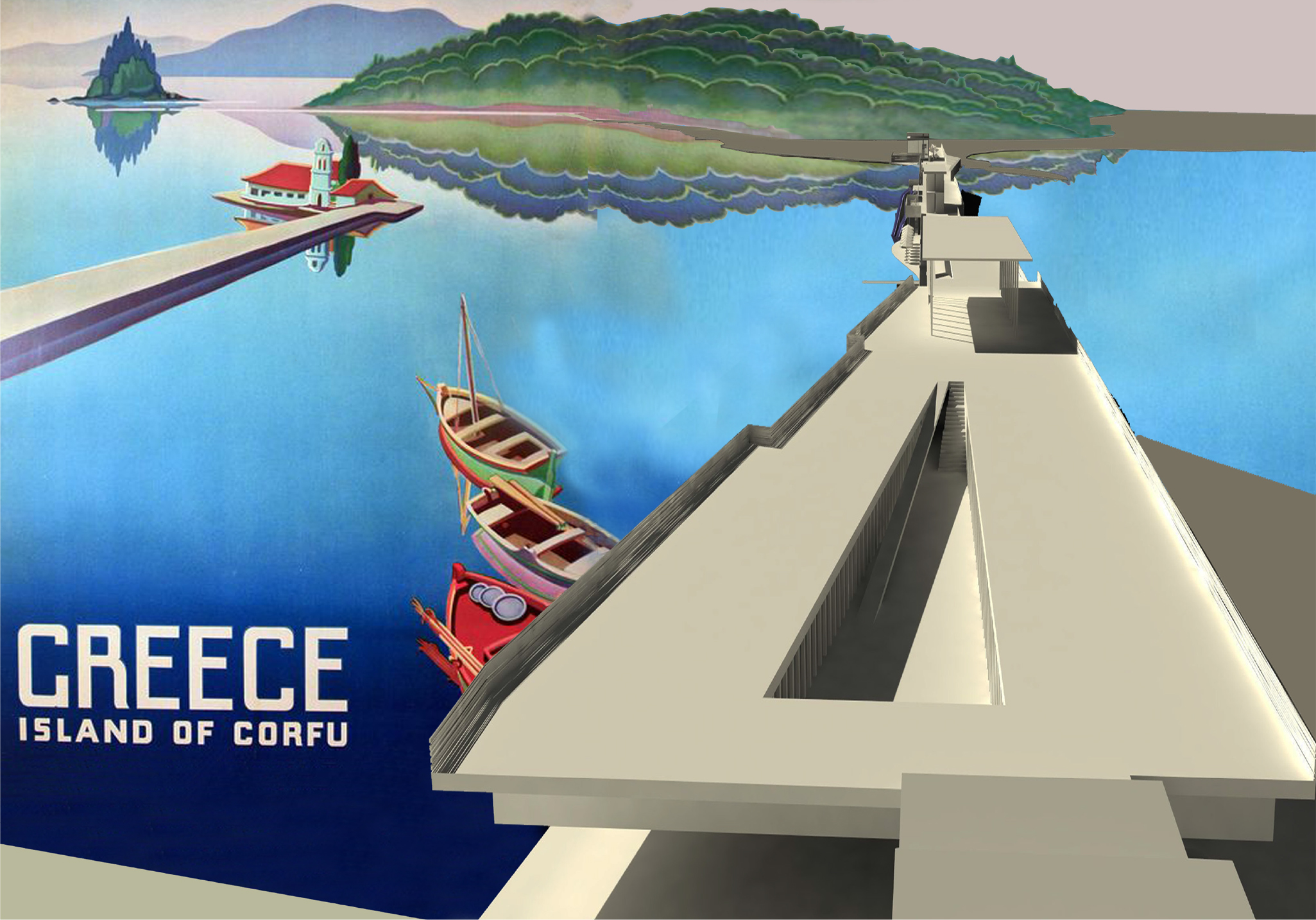
Sea Lane(s)
Kanoni, Corfu,GR
Stella Andronikou, Iasonas Giannopoulos
The site of intervention is located in-between two peninsulas -Kanoni and Perama- at the point where the natural reserve -the Chalikiopoulou lagoon- flows into the Ionian Sea. In adjacency to Greece’s second busiest airport, the scheme aims at transforming Kanoni into an all year round recreational hub both for tourists and locals.
The masterplan prescribes a 379m long pleasure bridge and floating park where a multiplicity of activities can be held. The multifunctional bridge will connect the two peninsulas and accommodate a restaurant, cafés, a low-cost hotel, an artificial beach, a playground, sport and recreation facilities, an amphitheatre and a kumquat orchard, along pedestrian pathways and a cycling route.
Furthermore, the masterplan foresees the redevelopment of the lagoon through the restoration of an aquaculture plant including a new fish cage system, storing and loading facilities. Along the lagoon’s coast, below the foliage of wild olive trees and orchards, a pedestrian and cycling route is created. A new dock and floating platforms will facilitate accessibility from the sea and provide areas for resting and experiencing nature.